Birmingham finds it's way
The Birmingham Post has reported New signs for Birmingham's business district with the installation of 15 wayfinding totems around the Colmore Business District (CBD) implementing plans first laid out in the Interconnect Birmingham Project developed in 2008, Joining the dots - Interconnect Birmingham.
The totems in the Colmore Business District were approved at the recent CBD AGM and will be constructed in partnership with Centro and the City Council and will be part of new totems and signposts providing wayfinding across the city centre.
The Interconnect project with it's strapline as a "Vision for a Walkable City" is aimed at improving the visitor and resident experience covering streetscapes and open spaces, urban structure to sightlines and street furniture to wayfinding with the first phase looking at wayfinding. The focus on wayfinding is toimprove street mapping and help people find their way around the city and create better mental maps of the city. With improved signage and accessibility it should encourage people to link different areas of the city and explore new parts of the city, http://www.marketingbirmingham.com/media_office/press_releases/8/2010/244/interconnect_birmingham/
Marketing Birmingham gained approval to utilise £8.809m European Regional Development Funds (ERDF) over the next three years from 2011-2014 and will link up with the Black Country and Solihull to encourage inward investment, business events and international visitor expenditure. The funding has allowed the development of the interconnect project which has been bolstered by the Big City Plan into reality improving the experience of residents and visitors.
The wayfinding project is aimed at reducing the percentage of visitors who are dissatisfied with signage and mapping from 23% dissatisfied in 2010 to 10% in 2014 through the installation of 85 ‘Interconnect’ digital information points and signposts in Birmingham, http://www.marketingbirmingham.com/about_us/investing_in_the_city_region__erdf_project/
The two images below are indicative of the wayfinding totems and improved signage posts that will be installed.
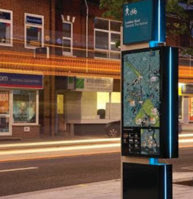
image reproduced from http://birminghamtoolkit.com/a-changing-landscape/interconnect-birmingham

image reproduced from http://www.marketingbirmingham.com/media_office/press_releases/8/2010/244/interconnect_birmingham/
Maps for these signposts will be developed from high resolution aerial photography supplied by Bluesky, Bluesky Aerial Photo Reveals Birmingham City Life. The aerial survey specialist Bluesky will supply high resolution aerial photography which will be used to create a royalty free base map which will form the base to create a map for the signposts.
“Topographical map layers such as building footprints and roads will be drawn, using the Bluesky imagery as the principle reference, and then styled creating a map that is fit for purpose and truly unique to Birmingham.” http://www.geoconnexion.com/geouk_news_article/Bluesky-Aerial-Photo-Reveals-Birmingham-City-Life/11440


Comments