Selly Oak New Road - April 2010 Update B
Following my preceding post, Selly Oak New Road - April 2010 Update A, this update includes pictures on the current developments to the Selly Oak New Road and works to link the new Queen Elizabeth Hospital to the road and information from BIRSE Civils who are the main contractors working on the site.
Letter from BIRSE Civils regarding work sent 18th March 2010 (reproduced from: http://www.sellyoaknewroadphase2.co.uk/12.html)

Newsletter concerning works, reproduced from: http://www.sellyoaknewroadphase2.co.uk/10.html.

View from island on Harborne Lane looking towards new Queen Elizabeth Hospital.


View towards Island, in my first picture, looking towards Selly Oak Church.

View looking across to the works on the plateau for the construction of the new railway bridge.

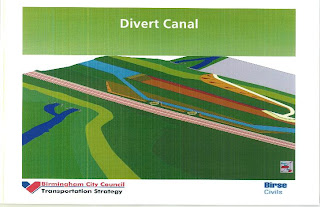
The works to construct the plateau can be seen in this presentation by BIRSE Civils to Birmingham City Council on Structure 3A & 3B, Rail/Canal bridge works. Reproduced from: http://www.sellyoaknewroadphase2.co.uk/9.html


Letter from BIRSE Civils regarding work sent 18th March 2010 (reproduced from: http://www.sellyoaknewroadphase2.co.uk/12.html)

Newsletter concerning works, reproduced from: http://www.sellyoaknewroadphase2.co.uk/10.html.

View from island on Harborne Lane looking towards new Queen Elizabeth Hospital.


View towards Island, in my first picture, looking towards Selly Oak Church.

View looking across to the works on the plateau for the construction of the new railway bridge.

The works to construct the plateau can be seen in this presentation by BIRSE Civils to Birmingham City Council on Structure 3A & 3B, Rail/Canal bridge works. Reproduced from: http://www.sellyoaknewroadphase2.co.uk/9.html


Comments
And where did the idea to call the old one a completely out-of-standard "B38"?
Oh, and the width of that tarmac is easily enough to accomodate 4 lanes of motor traffic... was there really a need for a cycle path on BOTH sides, using up the width that could instead have gone towards a simple central barrier?